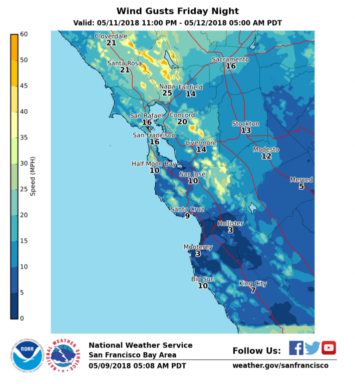
An early season offshore wind event will occur Friday Night. Strong Winds are predicted Friday Night for North and East Bay Hills. This is an unusual early season wind event with the potential to contribute to wildfires. A Red Flag Warning has not been issued due to the relatively high moisture levels present in local vegetation, however precautions should be taken. Follow Fire Safe Marin‘s Wildfire Preparedness Weeks steps TODAY!
UPDATED INFORMATION
- This is the first issuance for the upcoming wind event
IMPACTS
*Impact 1 (Strong winds) : (see attached gust graphic)
- Strongest winds arrive around 8 pm Friday night in the Napa Hills
- Winds spread over the East Bay, Marin and Santa Cruz mountains Friday Night
- Sustained winds 20-35 mph with frequent gusts in excess of 50 mph
- Weakened trees, limbs and power lines may be compromised.
*Impact 2 (Possible Wildfires):
- Wind driven fires will be possible during period of peak winds.
- Fuels are still fairly moist so fire will need strong winds to actively spread
- Temperatures during the day Friday will be one of the hottest days so far this year.
- Low night time humidity recovery is expected due to strong winds and good mixing
*Impact 3 (Beach Safety):
- Warm temperatures Friday and Saturday may bring extra people to area beaches.
- Cold ocean temps and constant ocean hazards such as rip currents and sneaker waves can be deadly.
Current Watches/Warnings/Advisories:
- A High Wind Watch has been posted for the North and East Bay Hills Friday Night.
- Quick look at all hazards in the state: http://1.usa.gov/1boSTTW
FORECAST CONFIDENCE
- Confidence is moderate at this time due to the event still being 3 days out.
TIMING
- Strongest winds Friday night. Dry weather the next 7 days.
- Hottest day will be Friday.
LOCATIONS
The hills of the North and East Bay, especially above 1500 feet as well as the highest ridges of the Santa Cruz mountains later Friday night.


