IN THE EVENT OF AN EMERGENCY THIS SITE IS NOT MONITORED. FOR CURRENT INFORMATION GO TO HTTPS://EMERGENCY.MARINCOUNTY.GOV.
Diablo Winds
“Diablo wind” is the name that describes the hot, dry winds from the northeast that sometimes occur in the San Francisco Bay Area of Northern California, especially during the spring and fall. The same wind pattern also affects other parts of California’s coastal ranges. The term first appeared shortly after the 1991 Oakland firestorm, perhaps to distinguish it from the comparable, and more familiar, hot dry wind in Southern California known as the Santa Ana winds. In fact, in decades previous to the 1991 fire, the term “Santa Ana” was occasionally used as well for the Bay Area dry northeasterly wind, such as the one that was associated with the 1923 fires in Marin, Sonoma, Napa, and Berkeley. The scientific term for this pattern is “Foehn winds.”
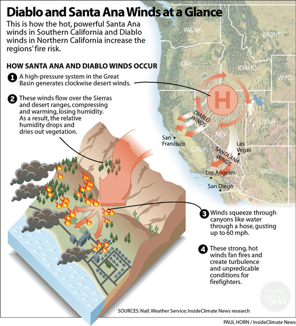
The name “Diablo wind” refers to the fact that the wind blows into the inner Bay Area from the direction of Mount Diablo in Contra Costa County, and is mindful of the fiery, romantic connotation inherent in the term that translates to “devil wind.” The Diablo wind is created by the combination of strong inland high pressure at the surface, strongly sinking air aloft, and lower pressure off the California coast. The air descending from aloft as well as from the Coast Ranges compresses as it sinks to sea level where it can warm as much as 20 °F (11 °C), and loses relative humidity.
Because of the elevation of the coastal ranges in north-central California, the thermodynamic structure that occurs with the Diablo wind pattern favors the development of strong ridge-top and lee-side downslope winds associated with a phenomenon called the “hydraulic jump“. While hydraulic jumps can occur with Santa Ana winds, the same thermodynamic structure that occurs with them typically favors “gap” flow more frequently. Thus, Santa Anas are strongest in canyons, whereas a Diablo wind is first noted and blows strongest atop and on the western slopes of the various mountain peaks and ridges around the Bay Area, although channeling by canyons is also significant.
In both cases, as the air sinks, it heats up by compression, and its relative humidity drops. This warming is in addition to, and usually greater than, any contact heating that occurs as the air stream crosses the Central Valley and the Diablo Valley. This is the reverse of the normal summertime weather pattern in which an area of low pressure (called the California Thermal Low) rather than high pressure lies east of the Bay Area, drawing in cooler, more humid air from the ocean. The dry offshore wind, already strong because of the offshore pressure gradient, can become quite strong with gusts reaching speeds of 40 miles per hour (64 km/h) or higher, particularly along and in the lee of the ridges of the Coast Range. This effect is especially dangerous with respect to wildfires as it can enhance the updraft generated by the heat in such fires.
While the Diablo wind pattern occurs in both the spring and fall, it is most dangerous in the fall, when vegetation is at its driest.