IN THE EVENT OF AN EMERGENCY THIS SITE IS NOT MONITORED. FOR CURRENT INFORMATION GO TO HTTPS://EMERGENCY.MARINCOUNTY.GOV.
Fire Detection Cameras
About the ALERTCalifornia Program
Based at the University of California San Diego, ALERTCalifornia manages a network of more than 1,144 monitoring cameras and sensor arrays (as of January 2025), and collects data that provides actionable, real-time information to inform public safety.
These cameras help to:
- Quickly discover, locate, and confirm fires;
- Dispatch firefighters quickly and appropriately;
- Monitor existing fires until they have been extinguished;
- Provide information that influences evacuation orders.
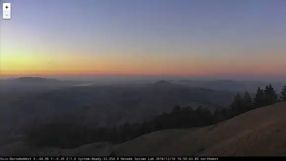
ALERTCalifornia’s high-definition cameras are able to pan, tilt, zoom and perform 360-degree sweeps approximately every two minutes with 12 high-definition frames per sweep. The cameras also provide 24-hour monitoring with near-infrared night vision capabilities. Each can view as far as 60 miles on a clear day, and 120 miles on a clear night.
In addition to the camera network, and in response to increasingly frequent and severe climate-driven disasters, ALERTCalifornia is prioritizing novel data collection and research. These data are open-source and are shared with fellow institutions and partners.
Today, Marin County is equipped with 12 wildfire detection cameras that provide 24/7 coverage, with additional support from neighboring counties’ camera networks. These cameras are powered by AI that continuously learns and improves, delivering immediate alerts when smoke is detected. This technology has proven to be highly reliable for early wildfire detection, giving fire agencies an edge in responding to potential threats.
*While Fire Safe Marin and Marin County Fire Department offer a limited “live” view of the cameras online, we want to remind residents and visitors that the view on our website is NOT the full display available to fire managers, and is NOT intended for the public to monitor their neighborhoods for fires or provide evacuation information!
Fire Detection Camera History
In 2023, CAL FIRE, ALERTCalifornia, and industry partner DigitalPath developed a new AI system that provides early wildfire confirmation and actionable real-time data to quickly scale fire resources, helps evacuations through enhanced situational awareness, and monitors fire behavior. The AI platform is a new tool in the toolbox and allows data to drive firefighting decisions, which saves lives, protects habitats, and infrastructure. In its first season, the AI platform was utilized in all 21 CAL FIRE Dispatch Centers and detected over 1,200 fires across California, beating 911 call reporting over 30% of the time. It is especially effective in spotting anomalies in remote locations and is proven effective at night.
Fire Cameras
ALERTCalifornia’s high-definition cameras are able to pan, tilt, zoom and perform 360-degree sweeps approximately every two minutes with 12 high-definition frames per sweep. The cameras also provide 24-hour monitoring with near-infrared night vision capabilities. Each can view as far as 60 miles on a clear day, and 120 miles on a clear night. Using the cameras and associated tools, first responders with the California Department of Forestry and Fire Protection (CAL FIRE) can rapidly confirm fire ignition, quickly scale fire resources, support evacuations through enhanced situational awareness and monitor fires through containment.
Infrared FLIR Camera Technology
This advanced camera technology allows firefighters to see fire through smoke, enabling better real-time resource allocation and enhancing firefighter safety. FLIR stands for “Forward Looking Infrared,” and refers to the thermal imaging technology used to create an infrared image of a scene without having to “scan” the scene with a moving sensor, an advancement over older models. FLIR technology is typically used on military and civilian aircraft, and is now being incorporated into ALERTCalifornia’s network.
Artificial Intelligence (AI)
ALERTCalifornia collaborated with the California Department of Forestry and Fire Protection (CAL FIRE) and industry partner Digital Path to create a fire detection AI tool with the goal of improving firefighting capabilities and response times. The value of this public-private partnership is the development of AI to aid firefighters, mitigate watchstander fatigue, reduce false positives, and confirm fire incidents in the incipient phase.
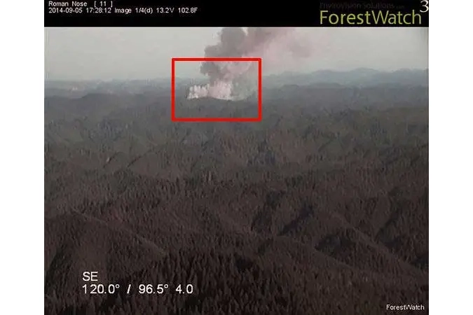
When the AI spots a potential fire on ALERTCalifornia’s network of cameras, the system alerts firefighters and provides a percentage of certainty and estimated location for the incident. If the incident is vetted and confirmed by trained watchstanders, firefighters respond quickly to extinguish the fire at the incipient phase. The camera network is also used to provide actionable real-time data to quickly scale fire resources, help evacuations through enhanced situational awareness, and monitor fire behavior.
Early detection and rapid response allow firefighters to combat fires before they grow. The AI tool became available to all 21 CAL FIRE 911 Dispatch Centers in September 2023. This new tool is especially effective in spotting anomalies in remote locations and is proven effective at night, even alerting firefighters before 911 calls.
In 2018, Marin County Fire Department partnered with PG&E and ALERT Wildfire to update and upgrade the Fire Detection Cameras. ALERT Wildfire is a consortium of three universities–The University of Nevada Reno (UNR), University of California San Diego, (UCSD) and the University of Oregon (UO)–providing access to state-of-the-art Pan-Tilt-Zoom (PTZ) fire cameras and associated tools to help firefighters and first responders:
- discover/locate/confirm fire ignition,
- quickly scale fire resources up or down appropriately,
- monitor fire behavior through containment,
- during firestorms, help evacuations through enhanced situational awareness, and
- ensure contained fires are monitored appropriately through their demise.
“PG&E and Fire Safe Marin worked hard to secure this critical funding,” said Todd Lando, Coordinator for Fire Safe Marin in 2014. “Our partnership with PG&E and Marin County Fire Department provided the opportunity to improve the County’s wildfire detection and monitoring capabilities, supplementing the daytime-only volunteer fire lookouts with 24-hour coverage, and views from additional peaks in northern and West Marin.” Fire Safe Marin will donate the system to the County of Marin.
The remote fire detection system enables Marin County Fire Department to monitor and detect wildfires around the clock, covering a larger land area than was visible from the two human-staffed fire lookouts at Mt. Tamalpais and Mt. Barnabe. Cameras and networking equipment are installed at the Gardner Fire Lookout on Mt. Tamalpais’ East Peak, the Dickson Fire Lookout on Mt. Barnabe near Lagunitas, Big Rock Ridge, and Mount Vision near Point Reyes. The upgraded system provides for enhanced fire protection for residents and businesses during Marin’s fire season.
Historic Lookouts
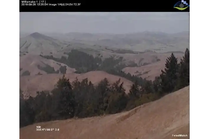
Marin’s historic fire lookouts at Mt Tamalpais and Mt Barnabe are currently staffed by a corps of volunteers during the daytime only. Marin County Fire Department intends to continue the volunteer lookout program, supplementing volunteers with the ForestWatch® system, and giving fire managers a new tool that allows them to see what the lookouts see, day or night.
Statewide, CAL FIRE has responded to more than 5,000 wildfires since January–about 1,000 more than average for this time of year. October is historically the peak of the wildfire season, highlighted by the Vision Fire near Inverness on October 3, 1995 burning 12,000 acres and 45 homes, and the Oakland hills ‘Tunnel Fire” on October 20, 1991 which to this day is the most destructive wildfire in US history, burning 3,354 homes.
About ALERT Wildfire
Program Funding
ALERT Wildfire is an expansion of the first network, ALERT Tahoe, which was a pilot program deploying PTZ cameras and microwave networks in the region surrounding beautiful Lake Tahoe. This initial project was funded through the Nevada Seismological Laboratory (NSL) at UNR, the Tahoe Prosperity Center, the Eldorado National Forest, and the USFS Lake Tahoe Basin Management Unit.
Soon thereafter, through a contract with the Nevada Bureau of Land Management, the network quickly grew eastward into northern Nevada where the BLM Wildland Fire Camera Project was born.
With growing successes in the summers of 2014-16, new contracts with the Oregon-Washington and Idaho Bureaus of Land Management, and San Diego Gas and Electric (SDG&E), provided further expansion of new fire cameras and microwave locations, and core university participation as UCSD and UO came aboard.
Sonoma Water, Southern California Edison, Pacific Gas and Electric, CALFIRE, NV Energy, and many counties, including Marin, Sonoma, Contra Costa, and San Luis Obispo have joined ALERT Wildfire to make a statewide network in California a reality.
Due to overwhelming interest in ALERT Wildfire technology, WildfireLIVE, a Nevada C-corp, was spun out of the Nevada Research and Innovation Corporation at UNR to not only help scale university-based operations within their original footprint, but to expand to other markets such as Utah and Australia.
ALERTCalifornia now receives funding from a variety of sources to support its operations and expansion, including
:
- Government Agencies:
- CAL FIRE: Provides significant funding to ALERTCalifornia, including a recent $10.4 million investment through the California state budget. CAL FIRE has invested over $20 million in the program in the last four years, with a commitment for future funding.
- Office of the California Governor: Offers support to the ALERTCalifornia program.
- National Science Foundation: Provided initial funding for the network.
- Utility Companies: Settlements from electric utility companies contribute to ALERTCalifornia’s funding.
- Private Businesses: Businesses such as Conifer Communications contribute financially.
- Federal and State Grants: ALERTCalifornia receives funding through various grant programs.
- Partnerships and Collaboration: ALERTCalifornia works with local, regional, state, and federal government agencies to strategically install new cameras, and these collaborations may involve cost-sharing or resource allocation.
- Other Sources: ALERTCalifornia also receives funding from unspecified “other sources”.
In summary, ALERTCalifornia relies on a diverse funding model involving state government agencies (primarily CAL FIRE and the Governor’s Office), federal grants, utility settlements, private businesses, and other partners to sustain and expand its public safety infrastructure and research initiatives.
Putting Fire Detection Cameras to Work
During the 2016-2020 fire seasons, ALERT Wildfire provided critical information for over 1,500 fires, including:
- the LNU, SCU, CZU, August and North Complex Fires in 2020;
- the Kincade, Cave, Maria, Saddleridge, Woolsey, Lilac, Wall, Whittier, Thomas, Tule, Woodchuck, Earthstone, Draw, Snowstorm, Hot Pot, and Emerald fires;
- an arson spree in Lake Tahoe in 2016;
- and hundreds more.
In late 2017, the devastating North Bay Complex and Thomas fires brought into sharp focus the need to quickly expand coverage across the western US. Two years later, the ALERT North Bay network provided real-time monitoring of the Kincade Fire from inception and helped provide an environment where no lives were lost nor injuries in the first 24 hours of the fire during wide-spread evacuations–a first for a large escaped, wind-driven fire in California.
The loss of life and infrastructure, especially in 2017 and 2018, has only strengthened our resolve to implement a comprehensive network throughout the western US. Although the three partner universities had been building their own redundant microwave networks to reliably acquire imagery, it became obvious that deploying new infrastructure to cover large areas in a short period of time was not realistic.
Expanding Fire Detection Camera Coverage
A new strategy was adopted in early 2018 to install cameras on existing third-party microwave networks, build larger virtual networks, produce regional coverage, and do it quickly. In this model, “towers of opportunity” (e.g., Wireless Internet Service Providers, state and county services, and other private point-to-point communications infrastructure) are outfitted with fire cameras and associated equipment to potentially allow 100+ fire cameras to be installed in a single season. The data from these confederated networks are seamlessly incorporated into NSL’s back-end acquisition systems and presented on our Amazon Web Services website in a straightforward manner.
To firefighters and first responders, it means “more cameras, more quickly”, which equals better decision-making capabilities. Now dozens and dozens of cameras can be installed in a single month. 300 new cameras were installed in the year following the Camp Fire (2018) in California alone, with another 300 new cameras in the Western US during the historic 2020 fire season.
The state-focused program now manages a network of more than 1,144 monitoring cameras and sensor arrays (as of January 2025), and collects data that provides actionable, real-time information to inform public safety. In addition to the camera network, and in response to increasingly frequent and severe climate-driven disasters, ALERTCalifornia is prioritizing novel data collection and research. These data are open-source and are shared with fellow institutions and partners.
In 2023, CAL FIRE, ALERTCalifornia, and industry partner DigitalPath developed a new AI system that provides early wildfire confirmation and actionable real-time data to quickly scale fire resources, helps evacuations through enhanced situational awareness, and monitors fire behavior. The AI platform is a new tool in the toolbox and allows data to drive firefighting decisions, which saves lives, protects habitats, and infrastructure. In its first season, the AI platform was utilized in all 21 CAL FIRE Dispatch Centers and detected over 1,200 fires across California, beating 911 call reporting over 30% of the time. It is especially effective in spotting anomalies in remote locations and is proven effective at night.