By ADRIAN RODRIGUEZ | arodriguez@marinij.com | Marin Independent Journal
PUBLISHED: January 2, 2023 at 10:56 a.m. | UPDATED: January 2, 2023 at 10:57 a.m.
For the first time, more than half of the rural and unincorporated areas in Marin County could soon be classified as “high” fire hazard severity zones, according to a proposed map from the California Department of Forestry and Fire Protection.

State officials unveiled the new map — which ranks the likelihood of certain areas to experience wildfire as “very high,” “high” or “moderate” — in December and are taking public comments through February.
If approved, more than 102,200 acres in Marin County will fall into the “high” fire hazard category, representing a 32.9% expansion since maps were last updated in 2007. Another 26,200 acres will fall under the “very high” category, the worst ranking from the Office of the State Fire Marshal, a 9.3% increase from the last update.
“What we’re seeing here is no surprise,” Marin County fire Chief Jason Weber said. “Based on the fire seasons the last 10 years or so, we know fire is spreading more rapidly and with greater intensity. The proposed maps are a more accurate representation of what we’ve been experiencing.”
The proposed Marin map covers about 200,000 acres that are within the state responsibility area, or the area for which the state is responsible for preventing and suppressing wildfires. The SRA is composed of primarily rural and unincorporated areas. It does not include federally managed areas, such as those overseen by the U.S. Forest Service, or cities and large urban areas managed by local governments. Such urban areas will be folded into a second round of map updates later this year.
Weber said the “very high” threat zones have primarily grown in the Mount Tamalpais watershed area between Mill Valley and Muir Beach, and in the area of Inverness and Marshall. Most of western Marin that used to fall under the “moderate” category will be changed to “high.”
An interactive feature on the Cal Fire website allows the user to see how the high and very high fire hazard severity zones have expanded in the proposed maps. Using a slider, the viewer can see a map that is mostly “yellow,” the color representing moderate, turning orange and red.
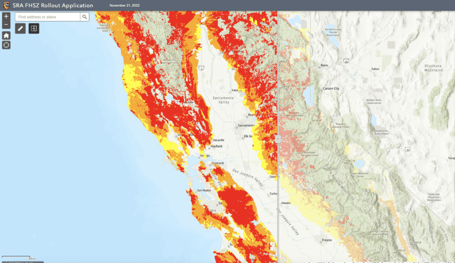
For comparison, more than half of California’s rural and unincorporated communities could soon be classified as “very high” fire hazard severity zones, according to the proposed map. That would place nearly 17 million acres under the worst ranking, a 14.6% increase since the map was last updated in 2007.
“While the results of the map aren’t necessarily surprising, they really are reflective of a changing climate and an increasing severity of wildfires,” Daniel Berlant, a Cal Fire official. The state map covers about 31 million acres that are categorized as the SRA, he said. The SRA represents about a third of California’s land.
The findings paint a stark portrait of the escalating danger posed by California’s blazes, which killed nine people in 2022, primarily in rural communities. The update puts nearly 55% of the state’s SRA acreage into the “very high” category, up from about 48% in 2007.
Among the counties with the biggest changes were Colusa, which had a 53% increase in its “very high” fire hazard areas; Yolo, which had a 51% increase; and Santa Clara, which had a 47% increase.
Napa had a 32.5% change in its “very high” fire hazard areas, covering about 73.4% of the SRA. In Sonoma County, there was a 21.6% increase in the very high areas, which covers 41% of the SRA.
In Los Angeles County, about 496,000 acres are considered state responsibility area. Of those, 93% were ranked as very high, 3.4% as high and 3.5% as moderate. The “very high” category had the most growth — a 14.2% increase since 2007.
According to Cal Fire, 12 of the state’s 20 largest blazes on record have happened since 2017. During 2020, the state’s worst fire year, more than 4.3 million acres burned.
Officials said the hazard map is based primarily on physical conditions — such as an area’s topography, vegetation and previous fire history — and is intended to show the likelihood of fire behavior over a 30- to 50-year period. It is not the same as risk mapping, which is used by insurance companies and can account for short-term efforts such as defensible space clearing and fire-resistant building upgrades.
Cal Fire said the map could help guide residents’ decisions about where to live and local governments’ decisions about where to build. It will not have direct implications for homeowners’ insurance, the agency said, although many residents in recent years have reported skyrocketing rates related to worsening fires.
California Department of Insurance spokesman Michael Soller said that in 2022 the state became the first in the nation to require insurance premium discounts for owners of homes and businesses that are made safer from wildfires.
He said updated hazard mapping was also among the recommendations in the agency’s first report on climate insurance, issued in 2021.
“It’s a benefit for the public,” he said.
Bob Ravasio, a Marin County real estate agent and former board member for the Marin Wildfire Prevention Authority, said property owners must provide documentation of defensible space compliance when they sell properties in high or very high fire hazard severity zones in accordance with state law.
“What we’re looking at for defensible space is more stringent than it ever has been,” Ravasio said. “A lot of what used to be advisory is now mandatory.”
Cal Fire plans public hearings on the draft map in the 56 counties that have state responsibility areas until Feb. 3, and the public is invited to weigh in and ask questions. Berlant said officials are particularly interested in scientific input.
A public hearing for the proposed Marin County SRA map is set for 6 p.m. Jan. 26 at the former San Geronimo Golf Club at 5800 Sir Francis Drake Blvd.
Cities and other incorporated areas will undergo a similar process later and be added to the map in a second phase of the project. The final map is expected to be adopted this year.
More information is at bit.ly/3GwWHMs.